Pages

Showing posts with label Waitaki Valley. Show all posts

5 January 2018

Three Lakes of Waitaki

Beautiful lakes, unique limestone formations, barren rolling countryside, braided rivers - Waitaki Valley has it all!
We loved the Mackenzie country with its peaked mountains, turquoise lakes and tinder dry landscape but the Waitaki District was equally lovely in its own way.
Although geographically the two regions aren’t far apart they do have a few differences.
The first difference I noticed were the many mature trees bordering the lakes. Although like the Mackenzie district the landscape was dry and brown, overall the Waitaki Valley appeared greener. Perhaps there’s more irrigation happening and a better class of soil?
There are three main lakes in the valley. All man-made and created as part of the Waitaki Hydroelectric project.
Lake Benmore, created in the 1960s, was the first of the lakes.


Lake Benmore’s dam is the largest earth-filled water retaining structure in New Zealand. Benmore Power Station is the second largest hydro station in N.Z – Manapouri is the largest.

We drove to the top of the dam and stopped at the lookout to see the bottom part of Lake Benmore. There were a couple of boats on the lake but it was windy, much windier than Lake Aviemore below.


The head of Lake Aviemore is sheltered under Benmore's dam, making it a popular spot for boats and water skiers.


The dogs were feeling the heat, so we headed just below the dam to Lake Aviemore where it was sheltered and easy access for a swim. The water was warm, clear and very inviting – darn I left my togs at the rig!


Next we drove across Benmore's dam and stopped on the other side to look down the massive spillway.


The photo above was taken looking up at Benmore Dam, the white motorhome traveling across gives an indication of how huge the dam is.

We wound our way around ‘Lakeside Drive’ following the edge of Lake Aviemore. There were so many camping spots – some with only a few caravans, tents, and/or campervans and other spots were like tiny villages. Some campers were well set up - with wind shelters around their camp sites, boats parked along side, it all looked very organised and no doubt many precious memories in the making.

Lake Aviemore got windier as we traveled along, on one section of the lake we saw kite surfers and wind surfers reaching great speeds.


The third lake was Lake Waitaki. Lake Waitaki is the smallest, oldest and farthest downstream of the three man-made lakes of the Waitaki hydroelectric scheme. It's popular for water-sports and fishing.
It was good for me walking beside the dams because I’ve always had a fear of hydro dams, all that water and the speed and power that it can move. Hopefully having a basic understanding of how they operate, and being near the lakes and dams has made my fear lessen somewhat.


It was a good day out. We got home in time to have dinner and then packed the dog fencing away to get a head start on the next day ... off to explore Central Otago.

3 January 2018

NZ's LARGEST Castle - 'Campbell Park Estate'

A castle-style mansion built in 1876 isn't something you'd expect to see down a quiet, country road in Otekaieke in the Waitaki Valley.


It's the biggest castle in New Zealand, with an interesting history. Dating back to 1857 an Otago run holder named William Dansey bought a sheep and cattle station that would later become 'Campbell Park Estate'.
In 1861 Dansey built the first house, 'Dansey's Hut' and then later that year sold the property to Robert Campbell the son of a wealthy Scottish family.
In 1868 Campbell married and although he lived in a two story-house, he decided it wasn't big enough so had a workforce of Scottish craftsmen shipped from Scotland, plus materials from Italy and Scotland were also shipped over. Campbell sent his wife, Emma Hawdon, back to England temporarily while the 35-room limestone castle was built.
Robert Campbell died in 1889 aged 47 years, and a year later his wife Emma died - they had no children to pass the property on to, so the estate was sold to the New Zealand Education Board and became 'Campbell Park School for boys'. 
Then in 1987 the boys school closed and the estate was passed into private ownership. Campell Park Estate has hosted movie production crews, multiple sporting events, musical, arts and cultural festivals.
In 2015 the property was up for sale again and was purchased by a Chinese-owned company. The Chinese plan to create an educational facility for Chinese students as well as tourist accomodation.


Campbell Park Estate really does look impressive and while I was researching about it, I discovered it includes; 32 homes , an educational campus with dormitories, kitchen facilities, an administration block, 7 classrooms, a library, a theatre, a gym, swimming pool, tennis courts, workshops and a number of historic buildings.
There are also old stables, a large restored villa, two smaller Oamaru stone buildings, an orchard and gardens.


To get there we drove along 'Special School Road' which is off the Kurow-Duntroon Road (State Highway 83). Unfortunately the estate is closed to the public so I had to make do with taking photos from the side of the road.


1 January 2018

Earthquakes - Yes, It's A Place!

When I heard there was a place named ‘Earthquakes’, I just had to go and have a look. Turns out it’s not a town as such –  it’s a geological site. The cliffs were once thought to have risen up from the ground as a result of an earthquake but in actual fact the land had slumped thousands or perhaps millions of years ago creating huge cliffs. 


You might be wondering where it is?
It's in the Waitaki Valley, between Kurow and Oamaru. Just west of Duntroon, turn into Earthquakes Road, which runs behind the Oamaru stone church on State Highway 83. The road is sealed and then becomes a gravel road – but it’s well maintained and it’s an easy and interesting drive through a countryside of strange geological formations.

After about three kilometres you’ll spot a sign for ‘Earthquakes’. And it's here you'll see the first information board.


After a short climb up a gentle slope across farmland you’ll come across an information board and a small cage containing fossils of whale-bones.


Strange to think the area was once beneath 100 metres of sea water but the fossils are proof that it's true.


The cliffs are high, huge and interesting looking with their unique, creamy-yellow rocky formations.


Luckily it was only a short walk and I was only away for about 10 minutes - there was a sign saying 'No Dogs', so Bernie decided to stay back at the ute with them and make some phone calls.


30 December 2017

Duntroon - Waitaki Valley

Duntroon is a small, historic town between Kurow and Oamaru. And it's obvious the community is proud of its heritage. Duntroon was established around 1864 and named after Robert Cambell who was born at Duntroon in Scotland. He came to New Zealand in 1860 and became a land owner.


Situated on State Highway 83 is the eye-catching St Martin's Anglican Church, built from limestone quarried from the North Otago region. 


Pretty in pink ... painted this colour, it would be hard to miss this cafe


Nicol's Blacksmith is one of the few remaining blacksmith shops in New Zealand. It's been part of Duntroon township for over 100 years and was named after the last working Duntroon blacksmith, Nicol Muirden. 
In 1975 four local farmers bought the building and its artefacts - about 30 years later the building needed to be restored, so in 2006 'Nicol's Blacksmith Historic Trust' was formed. In 2015 it was fully restored and a community celebration was held for its re-opening. 


Behind the blacksmith building is a Moa made from scrap metal - the legs were made from hydraulic rams, horseshoes form the neck and brass doorknobs were used as eyeballs. This monster Moa represents the estimated 90,000 Moas that once roamed the Waitaki Valley.


The fencing in front of the metallic Moa acts as a barrier to 'The Brewery Hole'. The Brewery Hole is a sunken limestone cavern created by an underground stream. According to local history the water's reflective surface was used as a mirror by young Maori women.


The beautifully restored Duntroon Gaol was originally built in 1910 - take a look inside to see what it would be like to be in a real police cell or try out the stocks.


The old train station below is now used for accommodation.


It's hard to imagine that 25 million years ago the land around Duntroon was the ocean floor. Extinct marine animals left their bones and over time have become fossilised. Now, they can be seen at Duntroon's Geological & Fossil Centre. 


There's a self-directed tour called 'The Vanished World Fossil Trail'. The trail introduces some key geological localities in the region.The Vanished World Centre and the Trail provide an understanding of 'deep time'. Interpretive panels are located at various sites explaining the origins of our land and its living creatures. 


 I bet this historic pub can tell a story or two! The old Duntroon Hotel.


Welcoming visitors to Duntroon are the limestone statues of a pioneering couple .


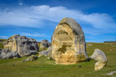
A short, picturesque drive and included in 'The Vanished World Fossil Trail' is a popular tourist attraction 'Elephant Rocks'. Elephant Rocks are unique geological limestone features, which are likened to a 'natural Stonehenge'. The large weathered rocks are scattered over a paddock on private farmland, with some friendly sheep to keep you company.


The lady in the photo below who is also taking a photo, gives an indication of how large these rocks are!


Looking across the Waitaki Valley, I imagined how spectacular it must look in every season. Autumn would be stunning, with its many shades of yellow, orange and gold - and as cold as winter would be in this region, I bet when it snows, it transforms into a winter wonderland.


About a kilometre along the road from the Elephant Rocks is 'The Anatini Fossil Site'. A short walk takes you to some baleen whale fossils that were buried at the bottom of the sea about 25 million years ago. Once upon a time, this area lay under 100 metres of sea water
This spot is where filming for a battle scene in the movie 'The Chronicles of Narnia' took place.


There's an information board in front of a plastic display case containing the baleen whale fossils. 


Below is the photo of the baleen whale fossils - it's a bit hazy because it was taken through a plastic covering.


To the left of the photo below, is the 'Alps2Ocean Cycle Trail, which is a 312 km long track beginning in the Aoraki/Mt Cook National Park and descending 780m through the Mackenzie Basin, down the Waitaki Valley to Oamaru and the Pacific Ocean. 


Heading back to Duntroon and driving west along State Highway 83 towards Kurow are the Maori Drawings. During their travels in this district early Maori used the limestone overhangs and caves for shelter. The rock faces provided an ideal surface for drawing using fat, charcoal and natural red ochre.


There were a couple of small information boards showing and explaining what the drawings were thought to be of. 


Although the Maori rock art was cool, I thought the little sparrows nesting in the limestone hollows made a neat tourist attraction too.


On the way back to the rig, I just had to stop and say hello to these bovine beauties! Don't you love their gentle expressions? Once I started chatting to one, the rest of the herd wandered over to see what was happening.


Duntroon was an unexpected delight - it's an area I'd highly recommend to stay for a night or two, or put aside a couple of hours to explore the unique landscape and special little township.