Pages

Showing posts with label glacial lake. Show all posts

11 October 2021

Known As One of the Most Beautiful Lakes in New Zealand.

Located about half an hour inland from Hokitika is Lake Kaniere, also known as one of the most beautiful lakes in New ZealandSurrounded on three sides by mountains and native forest, this glacial lake is almost 200 metres deep in places! Can you imagine how big the eels would be in a lake that deep? 

Lake Kaniere Reserve offers several walks ranging in length and is popular for camping, mountain biking, bird-watching, swimming, water-skiing, jetboating, and other outdoor activities. 


The first walk I took was the 'Canoe Cove' walk. It's an easy track and easy to find. As you drive along the eastern side of the lake, it's the first walk on the right. The track goes through a rimu and kahikatea forest to a sheltered inlet. 

Near the start of the walk are a couple of boardwalks over shallow, tea-coloured water. There's wire mesh covering the boards to provide grip ... the walkways must get pretty slippery at times.

I find it so uplifting walking in the bush - It's as though a weight gets lifted from my shoulders. There's no traffic noise, no hustle and bustle, just a feeling of peacefulness. The only sound was bird song, the air was filled with an earthy fragrance, towering native trees filtered the sunlight, and all around, plant life was thriving. Bliss.

Nature's artwork

At the end of the track, was a small sandy beach that curves around to an inlet. The lake was full when I visited so there wasn't much room between the water and bush but I managed to skirt around the edges without getting my feet wet.


Across the water, I spotted a rope hanging from one of the branches over the lake. Oh my goodness wouldn't that be so much fun in summer? If you click on the photo below (to enlarge it) you'll see the rope to the left.


Although it's only a short walk, it took me much longer than the suggested 15 minutes each way. I stopped a lot! - to look at fungi, to poke spongy, mounds of moss, to take photos, and to soak in all the beauty around me.

Bracket Fungi

Koru - the beginning of life


Back at the car, my car-key decided to play up! It's one of those remote thingies, where you press a button to open and lock the car. Before I had even pressed any button, the car started to unlock and lock itself over and over again. Luckily there was a 'normal' key inside the remote which I used to get into the car, but even inside the car, the door continued locking and unlocking repeatedly. In the end, I pulled the battery out and all was good.
After that wee predicament, I continued along the road to Hans Bay, which is a small settlement of about 50 houses. Most of the houses are holiday homes with views across the lake. 
Between the road and lake is a grassy area, the perfect place for a picnic and it's here that you'll find the boat ramp and a jetty for those who want to try their luck fishing. 


Also at Hans Bay is a DOC campground that's big enough for larger motorhomes/caravans, plus it has lakeside views. Unfortunately 'No Dogs' are permitted. 

Leaving Hans Bay and continuing eastwards along the lake's edge, the road changes to gravel. It's well maintained, although a little narrow at times. A few kilometres further up the road are the Dorothy Falls.

Dorothy Falls can easily be seen from the road - once over a little bridge, there's an area to park. It's a very short one-minute walk to the bottom of the falls, it'd be an ideal spot to cool off on hot summer days.


After taking a few photos, I jumped in the car and drove back the way I'd come. There's a fork in the road at the northern end of the lake. The road to the left travels along the western side of the lake, while the right turn leads to Hokitika. I decided to have a look along the west side of the lake. The road is called Sunny Bight Road and is about a kilometre long - it leads to the Sunny Bight picnic area which has views across the lake.


The next time I visit Lake Kaniere, I'll try to get there early morning, before there's any breeze. I'd love to see the reflections on a calm day. 


A sign from the rest area indicated that a short distance along the road was the beginning of the Lake Kaniere Walkway. It's a four-hour walk around the western shore of the lake, which ends at the southern end of Lake Kaniere on Dorothy Falls Road. I'll do that walk another time.

The road leading to Lake Kaniere Walkway.

Feeling recharged and rested, and with a camera full of photos, I headed back to Bernie and our two 4-legged kids.

15 December 2017

Picturesque Lake Pukaki

Whenever I see Lake Pukaki I'm in awe of its beauty. Huge snowy peaked mountains provide a stunning backdrop, while the turquoise blue water is truly breath-taking. 


On a day without wind the reflections are amazing.


Lake Pukaki was created by a receding glacier, huge glacial rock blocked the valleys. As it's glacial fed it has a distinctive blue colour, created by glacial flour (finley ground rock particles from the glaciers).
The lake's fed by the braided Tasman River which runs from the Tasman and Hooker Glaciers near Mount Cook. 


When we were staying at Lake Tekapo NZMCA park, Ian McGregor and his wife Vicky called in to meet us. Ian had messaged me in Methven to tell me about Awa Awa Reserve with lots of colourful rhododendrons growing amongst native bush. It was nice meeting up with them. When they heard we were hoping to find a place to stay at Lake Pukaki they suggested driving along Hayman Road,  there're lots of freedom camping spots all along the lakeside.


We found a great spot overlooking the lake - with gorgeous views from every window. If you're reading this Ian & Vicky, thanks for another great recommendation. It's perfect.


Not only do we love it here, the dogs do too. Paddy loves being near the water, although we're careful with how much he's in the water now since he became unwell. The two little dogs absolutely adore being in rabbit country. We've had to put the dog fencing up or we'd lose them down a rabbit hole.


The weather has been incredibly hot and although Lake Pukaki is a glacier fed lake, it hasn't stopped us from having swims to cool off. And we've been kayaking most days, it's pretty special paddling on clear, icy blue water and seeing Mount Cook at the head of the lake.


Other than us being in and on the lake the only other boat we've seen on it is the H2Explore Hovercraft. It seats 10 people plus a pilot. The hovercraft was constructed in Saint Petersburg by a Russian company. 


Using a hovercraft means the riverbed and shoreline won't need any structures as no launching platform is needed. It's the only vessel to travel between water and land without disturbing the natural riverbed.


The day we watched it, it was obvious they were experiencing some mechanical problems. It was making a tremendous noise and although capable of traveling at speeds of up to 70kms, on this particular day it was barely making headway.


Further along Hayman Road (about 500metres) is the Tekapo B Power Station. Huge penstocks come down from the hillside and enter the power station. Lake Pukaki is part of the Waitaki hydroelectric scheme. A canal running from Lake Tekapo feeds water into the power station on Lake Pukaki's eastern shore.


The penstocks carry the water from the canal into the power station. 


Just before the power station there's another road on the right, which leads to the salmon farms. Bernie caught a few salmon and was surprised at the size of some he saw swimming in the canal. I couldn't get a photo because he'd cut them into steaks before he came home. 

Bernie's daughter, Renee, came to stay for a few days. They had a special father/daughter time - kayaking, swimming, bike-riding and catching up. 


The sunrises and sunsets make the beginning and end of days extra special.

Sunset
Sunrise

The golden hour made the burnt, dried off grass around the rig a rich, golden colour.


I love the moods that the lake and weather bring. From dark, stormy skies to sunshine and people literally dancing for joy!


While we're staying in the area I'll try night photography. This area boasts one of the world's cleanest, driest and darkest skies. Perfect conditions for lots of practise. This photo was taken by resting my camera on a rock (at that stage I couldn't find my tripod, I knew I'd packed it but couldn't remember where!). Not ideal conditions because it was cloudy, so no shots of any stars.


9 December 2017

Hooked on Hooker Valley

Just south of the majestic Aoraki/Mount Cook is a glacial lake - 'Hooker Lake'. 


The track to Hooker Lake starts from 'White Horse Hill' camping ground. It's a DOC camp (no dogs allowed) and is in the Mt Cook National Park - only a stones throw from Mt Cook village. 
Obviously because of the dogs, we couldn't stay at the camp, so I set my alarm for 5am to get to the start of the 'Hooker Valley Track' nice and early for sunrise.
The first stop was along 'Mount Cook Road' on State Highway 80 - on the right is 'Peter's Lookout', it's a popular place to take a photo with Aoraki/Mount Cook in the background. Unfortunately the summit was covered in cloud while I was there.


It was a beautiful time to drive towards the mountain, the early morning sun cast a golden glow over the icy blue lake (Lake Pukaki) on one side and snow tussock on the other.


I arrived at Mount Cook Village before 7 o'clock so thought I'd have a quick look around. I found the school - Aoraki / Mount Cook School. It's the only school in New Zealand inside a National Park. The school has 9 children and one teacher and all children speak English as their second language.


It didn't take long to view the entire village. All the buildings and facilities operate on concessions and leases from the government. It's not possible to own property in Mount Cook village but because of the year-round running of hotels and motels, the village has a population of around 250.

Not far from the village, was the carpark beside the 'White Horse Hill' camping ground. I parked the car and enjoyed the company of several friendly rabbits. I noticed our motorhome friends, Neville & Barabra's campervan parked up - but it was too early to knock on their door to say hi.


Close to the beginning of the 5.5km long track is the Alpine memorial - a tribute to over 200 climbers that have lost their lives on the peaks around Mt Cook.


After I'd paid my respects, I wandered back to the main track and noticed others already ahead of me. A guy passed by who was returning from his walk - and I thought I'd had an early start!


Looking behind me, in the distance I could just see the 'The Hermitage' - an international style hotel in the Mount Cook Village. 


After about 15 minutes I came to the first of the three suspension bridges. To the left was the milky grey coloured, Mueller Lake.


Although the sun hadn't risen enough to fill the valley, the day felt warm - warm enough to wear only a t-shirt. The wind picked up and in the distance I saw swirls of dust being blown off the side of the mountain.


It was an easy walking track and well maintained. Enough space for passing, which was just as well with the amount of people walking it.


The second suspension bridge seemed higher than the first. The roaring water was raging underneath as it made it's way into Mueller Lake.


From the second swing bridge the vegetation changed to more open tussock and a wider valley floor. I was thrilled when I came across the Mount Cook lily. Well it's not actually a lily ... it's a buttercup - the world's largest buttercup. It can grow over a metre tall and has leaves larger than an adult's hand. The leaves are shaped like a cup and often hold water after rain.


The scenery was stunning - I was tempted to take photos every few steps (and basically that's exactly what I did!).


A long boardwalk led to the last of the suspension bridges, which crossed the source of the Hooker River.


A sign indicated, an alpine tarn to the right. And less than a hundred metres, the tarn appeared. Or what was left of it. There was very little water in it, which suggested even in this alpine zone there had been little rainfall.


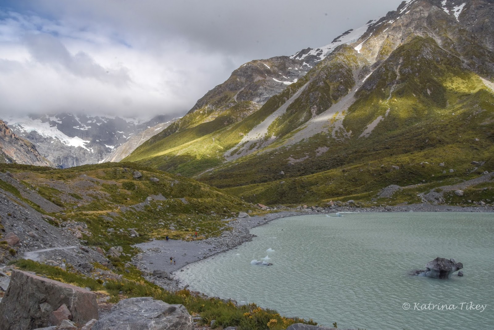
Back onto the main track and just over a small rocky incline was Hooker Lake. Complete with icebergs and milky glacial water.


I followed a short path down to the lake's edge, I was keen to touch the water. Yip - it was chilly!


I found a flat rock at the edge of the lake to sit, while I admired the scenery. Although some of the icebergs seemed as though they'd melt at any second, after feeling the water, I knew they wouldn't. I read somewhere the lake's temperature is usually lower than 2degrees.


Hooker Lake only began forming in the late 1970s when the Hooker Glacier started retreating. In 1990 its length was 1.2 kilometres and then in 2013 it measured 2.3 kilometres. The lake is expected to grow in length by another 4 kilometres as the Hooker Glacier retreats further up the valley. 


And guess how deep it is? 136 metres! Wow, that's deep ... I can only imagine how cold it is near the bottom.


I sat for awhile, taking it all in. Thinking of the many mountaineers who had lost their lives on the mountains and wondering what it was that attracted them to such a risky challenge. 


I was hoping the clouds would part so I could see Aoraki/ Mount Cook's summit (3724m) but that didn't happen. Aoraki meaning 'Cloud Piercer' didn't live up to its name that day.


A group of 20 or more boys arrived and started having competitions to hit the icebergs with rocks (typical teenage boys). They were from St Bede's College enjoying an end of year camp.


I decided to head back before the temperature got any warmer, we'd had a few scorching hot days and I wasn't keen to walk back in the midday heat. By this time the sun was filling the valley so the light was better for photos.


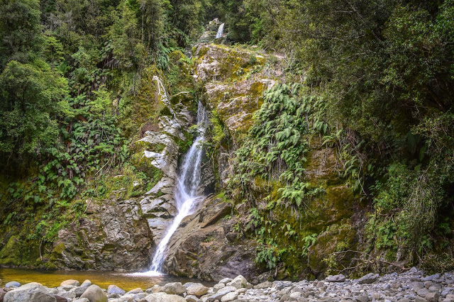
The glacial waters of Hooker River are a blueish/grey colour because of the glacial rock flour draining into it from Hooker Lake.


I kept looking over my shoulder, hoping Mt Cook's peak would become cloud free. Last night's weather forecast had predicted rain for the West Coast, so I guess the clouds were the result of that.


I admire how alpine plants can survive in such harsh conditions - they have to cope with extreme cold, windy and dry conditions. Often growing in infertile soil or shattered rock with huge changes in temperature.
Most of N.Z's alpine flora have white or yellow flowers because they're pollinated by flies, moths and beetles, which can't detect different colours.

An alpine hebe.
Golden speargrass (golden spaniard)
Mountain daisy (Clemisia)


On the walk back it was a challenge to get a photo without anybody in it - I was surprised by the amount of people walking the track. I passed two groups of 20+ people, escorted by an alpine guide, heading to the lake.


As I was almost at the carpark there was another short path that lead to 'Freda's Rock'. This special rock is the place Freda du Fair stood for the photo below.
Freda du Fair is a legend, a pioneer of mountaineering in New Zealand and Australia. In 1906, Freda traveled from Australia with her father for an International Exhibition in Christchurch and was captivated by photos and pictures of the Southern Alps. When it was time to head home to Australia - Freda headed for the mountains instead. And four years later in December 1910, she became the first woman to reach the summit of Mount Cook (with two guides, Peter and Alec Graham).


This was the same rock that Freda posed against for the photo above.
Near the carpark was a plaque on the site the first 'Hermitage' was constructed in 1884, to accomodate travellers and tourists. In 1911 a new hotel began to be built where today's Hermitage sits. Then two years later, in 1913 before the new hotel was completed a rare flood raced down the Mueller Glacier, bursting through the moraine wall and destroying the original Hermitage.


All up, the walk took about three and a half hours, plus an extra half an hour taking photos and stopping to stand in awe of the magnificent Hooker Valley landscape.