Pages

Showing posts with label Cromwell. Show all posts

25 May 2019

Over Lindis Pass to Cromwell

One of the many rewards of this trip has been seeing how diverse the South Island's landscape is. Sometimes, the contrast has been noticeable within a short distance. 
Lindis Pass is an example of this. It's barren, remote, unique and breath-taking. 


Lindis Pass Scenic Reserve was formed in 1976, and was one of the first tussock reserves in New Zealand. The road through the pass is hilly and winding and is about 60kms long. 


The rolling mountainside (with an altitude of 971m) is covered in tussock grass, and for many months of the year you can see snow, sometimes down to the side of the road.


Lindis Pass links the Mackenzie Basin with Central Otago and crosses a saddle between the valleys of Lindis and the Ahuriri River.


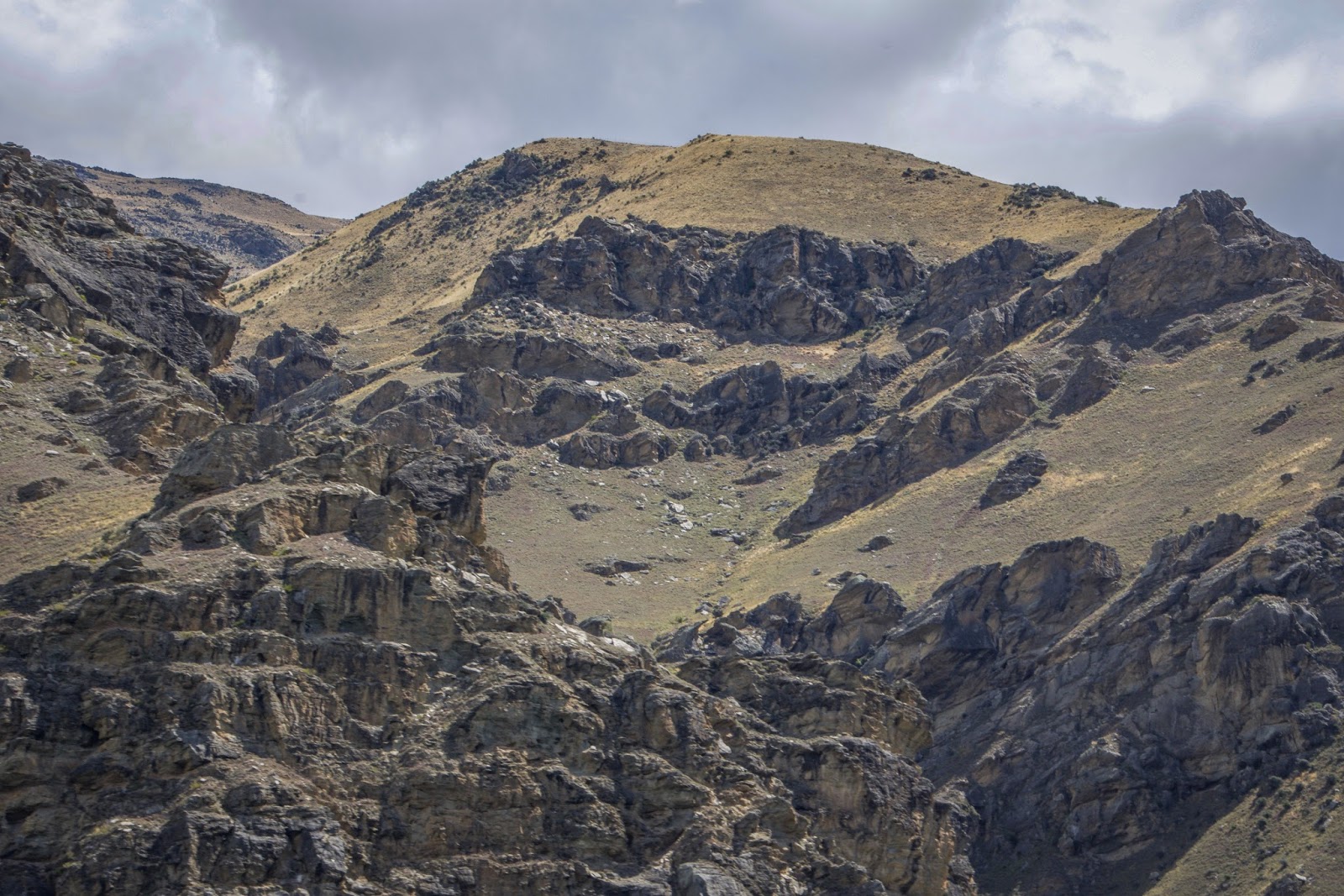
The little bus chugged up the pass without any trouble, the long stretches of road made it an easy climb. Once near the summit, I pulled over, it was time to give the dogs a break and for me to admire the view.


After the dogs had sniffed everything in sight and stretched their legs, we were back on the road. Before long, without looking at any road signs, I knew we were in Otago. 
How? The countryside gave it away - the distinctive craggy schist rock formations suddenly appeared along the countryside. 
I was rapt when we arrived in Cromwell. Finally, we were here, in the area, known for it's spectacular autumn scenery! 
I was hoping to stay at the Rotary Glen NZMCA Park beside Lake Dunstan, I had read reviews about it being a nice spot to stay, however it has a limit of 10 campervans. Knowing there were other places I could park if there were already 10 campers, I went to check it out.
Luckily, when I arrived there were only two others there. So I drove in and parked beside some spectacular golden poplars.


And, as we always do. It was off with the key. On with the gas. And then the three of us set off to explore.
Directly across from the park, was lovely Lake Dunstan.


Lake Dunstan is a man-made lake and reservoir which was formed on the Clutha River when the Clyde Dam was developed.
The lake provides irrigation to nearby stone fruit orchards and vineyards. It's also popular for swimming, boating, waterskiing, fishing and rowing.


Clearly the smell of rabbits in the air was strong. The dogs were eager to check out every bush and cluster of plants in sight.

We followed the edge of the lake for an hour or more and then turned back.


Parts of the foreshore was lined with Briar Roses. Their thorny branches were hanging heavily with bright orangey-red rose hips.


Legend has it Chinese Goldminers back in the 1860s brought briar roses to New Zealand as a source of vitamin C. The Otago winters were (and are) harsh and as rose hips have many medicinal uses, the Chinese used them as an aid to help them survive the cold winters.


During WW11, due to the lack of citrus fruit, rose hip gathering was a popular and meaningful pastime in autumn and early winter. 

Rose hips are the fruit of the briar rose and also contain the seeds. Rose hips are high in vitamin C, which assist with immunity. They also contain anti-inflammatory properties and evidence suggests these properties are effective in relieving symptoms associated with rheumatoid arthritis and osteoarthritis. 
Being rich in essential fatty acids (omega 6 and omega 3), makes them beneficial to skin care, e.g, dermatitis, acne, eczema, sunburn, scar tissue and wrinkles (*sigh* - if only I'd known that earlier, I would've collected bucket loads of those rose-hips and smothered my face with them! haha). I'll chalk it up, for another reason to come back and visit!


Birds and maybe rabbits, have helped disperse the briar rose seeds. Briar roses are considered a pest to farmers, they establish resistant thickets in poor pastures and can tolerate drought, hot to cold temperatures, and can thrive in low fertile soils. 


When we arrived back at the NZMCA Park, we were greeted by lots of rabbits. They barely glanced in our direction, obviously we weren't a threat.


The dogs were on their leads and they were truly mesmerised. They would've done anything to be let off!  


Honestly, I don't think Oakly slept at all that night! Every time I woke, he was sitting beside me with his face glued to the window. I could see the rabbit's silhouettes as they sat on the nearby ridge. Admittedly, they were entertaining, jumping in the air, twisting and spinning around (this cute behaviour is known as a 'binky'). Others were grooming themselves, licking their paws and rubbing their faces or just sitting still.

Thankfully, Oakly spent the whole night watching. He never made a noise. So Boo and I had a great night's sleep.

18 January 2018

Clyde - Central Otago

Contact Energy's camping area above Clyde Dam is a beautiful spot but it pays to pick your times. We arrived midday in the middle of summer. It was dry, dusty, windy and very busy. We were lucky to squeeze into what was possibly the last spot for a rig our size. It wasn't an ideal spot, we had the public road on one side and the camp road on the other. We were in the middle of them both and every vehicle that drove past showered us in dust. It was such a contrast after spending a week at a spacious domain in Waipiata and then being among lots of other camper vans. 


There was no room to put the dog fencing up so we kept the dogs inside and took them for swims to cool off. The water was only about 20 steps away - what a bonus!


Contact Energy has created a nice place for campers to stay - lovely views and I'm sure in autumn when the grass is green and the trees are changing colours it would be simply stunning.


The sound of horse hooves beside the rig made me dash for the camera. It was a horse trek passing through. The horses went both sides of the rig - if I had of put my hand out the window I could have patted them.


We were keen to escape all the dust and wind, so decided to move on the next dayWe'd been told about a beaut place to stay right on the water's edge at Lowburn. 
Lowburn is a small settlement five minutes north of Cromwell, it sits on the shores of  man-made Lake Dunstan. It wasn't far from Clyde dam (20 minutes), so we took a drive to check it out. 

Cromwell-Clyde Road (State Highway 8) winds its way beside the Clutha River towards Cromwell. Like most parts of Otago the scenery was amazing, dramatic mountains in the background with the mighty, emerald green Clutha River sweeping passed in the foreground. 

Trees in the foreground are blurry as photo was taken out of the car window - there wasn't an area we could pull over.

The Clutha River is the longest river in the South Island and the second longest river in New Zealand. The Maori name for the Clutha is Mata-Au, meaning surface current.


Along the Cromwell-Clyde Road, we noticed what looked like a giant, rocky amphitheatre on the mountainside. Turns out it's landslide stabilisation. When the Clyde dam was being constructed engineers were worried about landslides. If a landslide plunged into the Clutha  it could create a wave that could overtop the dam. 


A moving chunk of mountain hanging over Cromwell Gorge was causing problems. It's known as the Cairnmuir Landslide and it's one of many that needed to be stabilised before the dam was completed and Lake Dunstan was formed. 


Just before arriving at Lowburn we called in to see the Cromwell's NZMCA. It looked nice, but again it was very dry and dusty! Whirls of wind coated everything in dust. I'm sure it would be a nice place to stay but at this particular time it wasn't for us.


The dogs didn't need any persuading to have a swim - Lake Dunstan was clean, clear and inviting!


The next morning I took the dogs for a walk before it got too hot. I love that time of the morning. It's peaceful, with gorgeous golden light and not a soul in sight - and luckily there weren't any rabbits either!


I took a drive around Clyde township to take photos of the old buildings. It was Sunday morning so the town was quiet except for an alarm going off at one of the hotels.


Clyde was first known as Dunstan, named after the neighbouring Dunstan Mountains. It's a small historic gold-mining town nestled in a basin at the foot of a crooked gorge. 


I loved the novel idea of these 'Footprints in Time' plaques, which were placed along the footpath on Clydes main street.


This cute little stone cottage with bushes of fragrant lavender caught my eye.


Further up the road was a picnic area where the dogs enjoyed a walk and I admired the stunning views.


Looking towards the Clyde dam camp, you can just see the end of our rig tucked in behind the small cluster of trees in the middle.


Looking north up the Clyde River with SH8 running alongside.


The first sign of life on the water, was an early morning boatie heading in the direction of the dam.


Time was getting on, so I called the dogs and headed back to the rig. As usual I made a couple of stops on the way - one of them was at the iconic Clyde Bridge. 


The Clyde Bridge crosses the Clutha River and links Clyde to Earnscleugh. The steel-arched road bridge replaced the original bridge (which was built in 1881). The new bridge which opened in 1934 sits on the old bridge's piers. 


The photo below was looking down the Clutha River standing on the Clyde Bridge.


The next stop was at the Clyde dam. The Clyde dam is New Zealand's third largest hydroelectric dam and was built on the Clutha River. It's owned and operated by Contact Energy. There was a lot of debate about this dam being built because it would mean flooding many houses and orchards upstream at Cromwell. Making the dam would also require replacement of a stretch of highway and the Otago Central Railway beyond Clyde would close.
To appease public concerns the Kirk Labour Government decided to build a low dam but that decision was overturned by the following National Government who opted instead for a high dam. 
Creating the dam was a major budget blow-out! During construction the adjacent rock was found to be micro fractured because of an earthquake fault running beneath the dam site. The dam was redesigned, making it the most expensive dam in New Zealand.


It didn't take long to pack up the rig and hitch up. There were no dog fences to put away and because it had been so windy the night before we hadn't put any mats down outside. All that needed doing was to secure things inside and we were done. It was a quick get away!


Heading out of Clyde towards Roxburgh are lots of orchards with delicious, ripe, stone fruit smothering the trees. And yes, we stopped and bought peaches, nectarines, apricots and cherries. Yum-diddly-yum!