Pages

Showing posts with label native bush. Show all posts

12 October 2021

Worth the Wait!

The Hokitika Gorge has been on my ‘Must See’ list for a while. Last week, I was finally able to tick it off. Was it worth the wait? Absolutely!

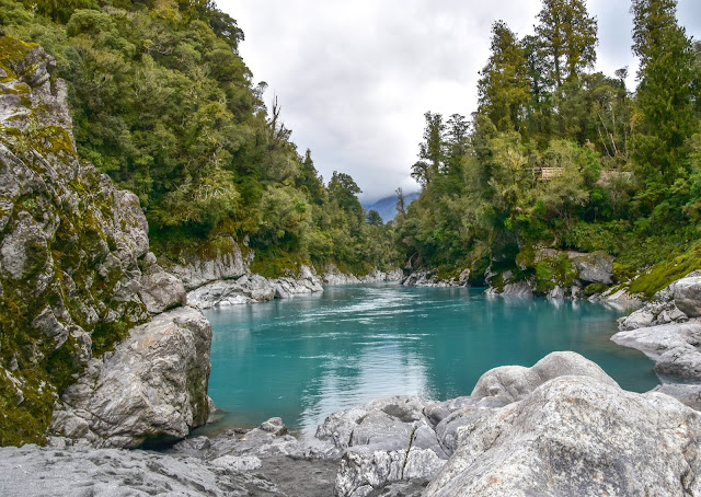
Leaving Hokitika, on the 30-minute drive to the gorge, I wondered if being a cloudy day might affect the colour of the water. I'd read the river is a brilliant teal colour on sunny days and a milkier, less vivid blue on cloudy days. But, it turned out, I had nothing to worry about. Sunshine or clouds, the Hokitika Gorge is stunning in any weather.


Despite it being the school holidays there were lots of empty car parks. Maybe that was due to there being fewer overseas tourists due to covid. 


I walked a short distance through native bush before arriving at a viewing platform overlooking the gorge. This is the spot that I’d seen lots of photos taken from. So, just like others before me, I lifted my camera and clicked away.


Continuing along the track, curved boardwalks lead to the first swing bridge. 


The swing bridge offered breath-taking views of turquoise water flowing past the rocky sides of the gorge. The contrast of the bluey-green water, the pale rocks, and native bush was spectacular. I could have stood on the swing bridge for hours admiring the view but had to move on when people arrived to cross the bridge. 


If you're wondering how the water gets to be this colour, it's because of 'rock flour'. Rock flour is
tiny particles of rock caused by the grinding of bedrock when glaciers erode. Because it's so small (smaller than sand) it's suspended in the water making it a milky colour.


A little further along was another viewing platform, which is upstream of the bridge. Beside the platform are steps leading down to a rocky beach. There’s a gate to open before getting to the steps and signs warning people of the dangers of swimming in the gorge. The river is very cold, dangerous and swift and has taken lives.


Looking towards the first swingbridge.

Wikipedia states ... The Hokitika Gorge was ground out of granite by the Hokitika River. 
A quote I read recently that seems fitting is ...
'A river cuts through rock, not because of its power, but its persistence.'


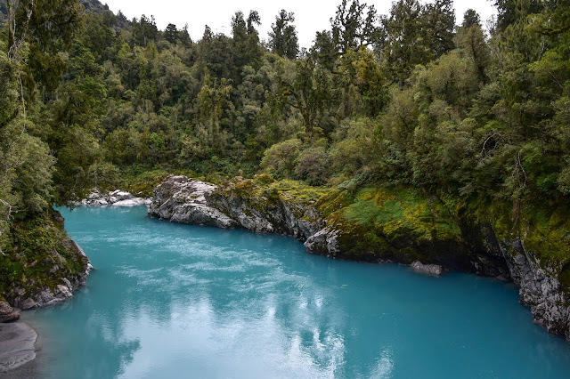
I continued walking further along the track, across more boardwalks, with glimpses of the river below. It wasn't long before I came to a second suspension bridge, recently built in 2020. At 90-metres long, it's one of New Zealand's longest suspension bridges (The Buller Gorge being the longest at 110 metres).  


To the right of the bridge, the foothills of the Southern Alps can be seen, while to the left is the view of the Hokitika Gorge.  


View from one side of the swingbridge - down the Hokitika Gorge.


Looking towards the foothills of the Southern Alps.


From the bridge, it’s an easy half-hour walk through native forest back to the car. I know two dogs that would have loved to have been with me on this walk, but it's DOC, so no dogs allowed.


Here's an interesting piece of information I found and copied from a DOC, Conservation Blog about moose being released at the Gorge in 1900.


Hokitika Gorge was the scene of the first release of moose in New Zealand in 1900 when fourteen moose calves were sent to New Zealand from Canada. Only four survived the journey and were released at the Gorge, adapting to the new conditions and diet under the watchful eye of a full-time minder. After a few weeks, the two bucks headed to the high country, while the two does took up residence in the lower reaches of the Gorge. According to legend, local farmer, Bert Cropp shot one of the moose after she made a nuisance of herself in the gardens around Kowhitirangi. Moose sightings were reported until 1914, and there is no evidence that they ever bred.


7 August 2018

Gold at the End of the Rainbow

I think we found the pot of gold at the end of the rainbow - or at least our block of gold. And for us, it was a couple of acres of native bush. 


After the rig sold we started to look for some land. 
Bernie loves having a project on the go, and enjoys pottering about creating things. Getting some land seemed to tick a few boxes for us. Bernie could build and we could use it as a base when we got back into motor-homing again.
We talked about areas in the South Island where we'd like to live. One was Otago, we both loved that region - but it's a long way from where we're currently living (and employed) so we limited our range to within an easy days commute from Nelson.
Initially we thought Westport would be the spot. It's Bernie's hometown and compared to Nelson, land is so much cheaper. So we made a list of potential properties and spent a couple of weekends looking around. Eventually we narrowed it down to a couple of possibilities but they seemed to be over priced for the area, so we extended our search.
Hokitika was an area we both liked and while looking on Trademe, we saw a section at Kumara Junction (15 mins north of Hokitika) that had been cleared of bush, ready for building, it had a water tank and a septic tank. It looked good. After making a list of other places to check out in the area we set aside a day to have a look. 
The Kumara Junction section looked okay but there was a small creek to the side of the section that concerned us due to possible flooding. 


After we left the section we went to Kamara Beach to have some lunch.


What a beach! A typical West Coast beach; rugged and isolated. 
There was sand for the dogs to dig (ah-ha, it's all about the dogs), lots of stones, some were pure white (which I love collecting) and all sorts of gnarly driftwood.


Kumara Beach also has it's claim to fame ...it's the starting point for the 'Coast to Coast' endurance race.


Bernie at the starting point...gumboots and all!

We had several more blocks of land to look at around Hokitika so we left the beach to continue the search. However the sections we saw were more like farm paddocks and we were wanting a bit of native bush.

Next we headed north, as we'd tagged a couple of bush blocks to see around Greymouth. As we were passing back through Kumara Junction, Bernie suggested we go back and check out the first section we'd seen (the one with the smaller creek).

Driving into the subdivision, we drove further on to see if there was anything else for sale. We must have timed it right, as there were a couple of ladies out for a walk and Bernie stopped to ask them if they knew of any other blocks for sale. Turns out they'd built in the subdivision two years ago and couldn't speak highly enough of the area. They gave us an address of a couple who would be able to give us more information. 
And to cut a long story short. 
We met the couple. 
They showed us several new blocks available.
We found one we both loved. 
And bought it.


Throughout the subdivision, there are wide roads, which are bordered with native bush. Part of the charm of this area is not being able to see any houses from the road and every driveway is long with a couple of curves to provide privacy from the road.


Below is a photo of the front view of the section we bought.


Look at all that native bush...


And a rainbow ... perhaps a sign!


Bernie, Bill & Amanda chatting about boundaries etc


The photo below is an arial shot. You can see how thick the native bush is - it's a mixture of rimu  kahikatea, punga, fern and a bit of manuka, so we'll clear out an area in the middle to build. 

There are only two covenants attached to the subdivision. One, is no burning coal (only wood), which makes Bernie so happy. Despite being a coal miner he hates the smell of coal!
The second condition is to leave at least 5 metres of bush around the boundary, which makes 10 metres of bush between you and your neighbour (at least). 
Absolutely perfect for us.