Pages

Showing posts with label Bush walks. Show all posts

23 February 2023

A Bush Walk - A Random Wall and A Very Close Call!

From the photos I've seen, Marble Hill Campsite looked like a nice place to stay. For awhile now, I've wanted to visit but it's a DOC camp and no dogs are allowed. However, recently I was passing by and the dogs weren't with me, so I stopped to check it out.


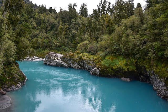
Marble Hill Campsite is located 5km east of Springs Junction, on Lewis Pass Highway (SH7). It's a large area suitable for any length campervan, with a selection of hard, flat areas to park, and little secluded nooks for the smaller campers and tents.

Near the end of the campsite, on the left, is a shelter and it's here that the popular Lake Daniell track begins, it's about 8kms one way and can be done in a day. The shelter is also where the Sluice Box Walk begins. The sluice box is a deep, narrow gorge along the Maruia River.  

The track winds through a beautiful beech forest. Every now and then I noticed a splash of colour, which stood out amongst the many shades of green and brown. Nature really is breathtaking!

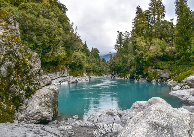
It wasn't long before I came to the Sluice Box Bridge. Usually, it's an easy 5 minute walk to the bridge, however I took a little longer because I kept stopping to take photos.

The colour of the water below was stunning.- another of nature's gems. 


As tempting as it was to continue walking, I had a long drive ahead. The rest of the walk would have to wait for another time.  


As I was nearing where I'd parked the car, I noticed a worn, grass track leading towards a low concrete, wall  - I went to investigate.


I'm pleased I did because I discovered this random concrete wall had been built for a purpose. The wall was built by scientists in 1964 and is 24 metres long and 1.4 metres high, with most of it underground. 


It turned out that the wall hadn't been randomly put there, it had been precisely placed to sit through the middle of the Alpine Fault. Scientists were monitoring movement in the Alpine Fault and their theory was if one side of the fault moved in relation to the other, it would be measured on the wall.


It's reassuring to note, since the wall has been there, it hasn't moved, and because there's been no movement in almost 60 years it indicates that the Alpine Fault doesn't make small movements. Instead like most active faults in New Zealand (and worldwide), it makes large movements!

And close to the wall, is a fenced area that Maruia School children have adopted as a restoration project for two vulnerable frost flat plant species.


Time was marching on, so I wandered back to the car, stopping to admire wildflowers amongst the grass.


Not far away were several campers nestled at the edge of the beech forest. It looked like a great spot!


I was pleased I'd spent a few hours exploring and can see why many people recommend it. 

Leaving the campsite, I stopped at the main road to give way. There were no vehicles on my left and on my right, I noticed a vehicle in the distance. So I pulled out. However, within seconds, I saw that the vehicle on my right was being over taken - the over-taking car must have been in a blind spot. I only had seconds to react, which strangely, at the time, felt longer. There was no option except to drive straight ahead, which fortunately happened to have a pull over area. I was literally seconds away from being hit and what surprises me to this day is how calm I felt in those split seconds.

However, afterwards, I didn't feel so calm. I kept replaying it over and over and questioned myself over an over. By the grace of God, I'd narrowly avoided being in an accident. It's been a wake up call. Check, check and check again!

Life could have changed so quickly.   

21 February 2023

First Overnighter

I decided to have the first night away in our 'new' bus not too far from home. Bernie was working so it was just me and the dogs.

After looking at the NZMCA app and reading posts in various Face book groups, I chose to go to a DOC campsite near St Arnaud - Teetotal Camp. First, and most importantly it was dog-friendly,  with several walks right beside the camp. Secondly, we hadn't been away overnight in this particular bus, I thought if I ran into trouble, I was only an hour from home.

We (Oakly, Boo and I) arrived just after midday on a hot summer's day. Only one other camper was there so choosing a spot to park was easy. I decided on an area beside some trees for some shade for the dogs.

As I mentioned, one of the reasons I picked Teetotal Camp was due to reading some Facebook posts. One post had shown photos of dogs in a river and with that thought in mind Oakly, Boo and I set off for a walk. Usually I don't walk the dogs during the day in summer as I'm mindful of how hot it can get for them. However they were itching to get out to explore and I figured they could cool down once we got to the river.


After walking for more than half an hour there was still no sign of a river. I thought of turning back, the dogs were hot and seeking shade to rest. However, I thought if we turned back they'd have to walk another half hour or more and still wouldn't get to cool down in the river. But, how far away was this river?

After some toing and froing, I decided to keep going, hoping the river wouldn't be too much further. Oakly is 13 now and in the last 12 months has started slowing up. Nowadays he likes to stop every few metres to smell everything in sight, so it was a slow walk.. 


In the distance I heard some dogs barking and when they appeared, along with their owner, I asked how far ahead the river was. She told me there wasn't a river ahead. Fortunately she lived in the area and suggested rather than returning on the same track, we follow a less trodden path. She knew the area well and explained the shorter route. So off we went.

Oakly handled the return-walk surprisingly well ... it was Boo who struggled, so I had to carry her some of the way. I felt awful having them out walking in this heat.

It was great to eventually see the campsite! 

And, after a nice, big drink of water we lay down to rest.

The dogs signal when they're ready for dinner - I never need to check my watch. It's alwaysbetween 4 and 5pm. When they indicated they were hungry, they ate in the shade and not long after were napping again.

I had a rough idea how to turn the inverter on so I could turn Netspeed on, but when I tried it didn't work. Normally, this is when I'd see if Bernie knew how. However, he wasn't there so I had to figure it out myself. I know it's not rocket science but the set up in this bus was different than our previous set-up. However I'm pleased to say, I figured it out!  Then I celebrated a successful day with a movie and wine.

Later that evening I messaged my Facebook friend to ask where the river was that she'd posted while staying at Teetotal. I laughed when I read her reply. Turns out, when she stayed there they took a day trip to Nelson and stopped at the Motueka River to give their dogs a swim. When posting photos of their time at Teetotal she'd included the Motueka River photos. LOL.

Wow, we could have walked for hours and not found a river! Thank goodness we stumbled across that local lady walking her dogs!

12 October 2021

Worth the Wait!

The Hokitika Gorge has been on my ‘Must See’ list for a while. Last week, I was finally able to tick it off. Was it worth the wait? Absolutely!

Leaving Hokitika, on the 30-minute drive to the gorge, I wondered if being a cloudy day might affect the colour of the water. I'd read the river is a brilliant teal colour on sunny days and a milkier, less vivid blue on cloudy days. But, it turned out, I had nothing to worry about. Sunshine or clouds, the Hokitika Gorge is stunning in any weather.


Despite it being the school holidays there were lots of empty car parks. Maybe that was due to there being fewer overseas tourists due to covid. 


I walked a short distance through native bush before arriving at a viewing platform overlooking the gorge. This is the spot that I’d seen lots of photos taken from. So, just like others before me, I lifted my camera and clicked away.


Continuing along the track, curved boardwalks lead to the first swing bridge. 


The swing bridge offered breath-taking views of turquoise water flowing past the rocky sides of the gorge. The contrast of the bluey-green water, the pale rocks, and native bush was spectacular. I could have stood on the swing bridge for hours admiring the view but had to move on when people arrived to cross the bridge. 


If you're wondering how the water gets to be this colour, it's because of 'rock flour'. Rock flour is
tiny particles of rock caused by the grinding of bedrock when glaciers erode. Because it's so small (smaller than sand) it's suspended in the water making it a milky colour.


A little further along was another viewing platform, which is upstream of the bridge. Beside the platform are steps leading down to a rocky beach. There’s a gate to open before getting to the steps and signs warning people of the dangers of swimming in the gorge. The river is very cold, dangerous and swift and has taken lives.


Looking towards the first swingbridge.

Wikipedia states ... The Hokitika Gorge was ground out of granite by the Hokitika River. 
A quote I read recently that seems fitting is ...
'A river cuts through rock, not because of its power, but its persistence.'


I continued walking further along the track, across more boardwalks, with glimpses of the river below. It wasn't long before I came to a second suspension bridge, recently built in 2020. At 90-metres long, it's one of New Zealand's longest suspension bridges (The Buller Gorge being the longest at 110 metres).  


To the right of the bridge, the foothills of the Southern Alps can be seen, while to the left is the view of the Hokitika Gorge.  


View from one side of the swingbridge - down the Hokitika Gorge.


Looking towards the foothills of the Southern Alps.


From the bridge, it’s an easy half-hour walk through native forest back to the car. I know two dogs that would have loved to have been with me on this walk, but it's DOC, so no dogs allowed.


Here's an interesting piece of information I found and copied from a DOC, Conservation Blog about moose being released at the Gorge in 1900.


Hokitika Gorge was the scene of the first release of moose in New Zealand in 1900 when fourteen moose calves were sent to New Zealand from Canada. Only four survived the journey and were released at the Gorge, adapting to the new conditions and diet under the watchful eye of a full-time minder. After a few weeks, the two bucks headed to the high country, while the two does took up residence in the lower reaches of the Gorge. According to legend, local farmer, Bert Cropp shot one of the moose after she made a nuisance of herself in the gardens around Kowhitirangi. Moose sightings were reported until 1914, and there is no evidence that they ever bred.


20 October 2018

Time For A Break

After losing our much-loved dog, ‘Paddy’ we decided to get away for a few days. 


We packed up the bus and headed over to the Coast, with a few stops along the way. The first stop was at Kawatiri Junction. And Bernie being Bernie, as soon as we parked, he put the jug on, while I took the dogs for a wander.


Kawatiri Junction is between Nelson and Murchison. It’s where SH6 and SH63 meet. There used to be a tiny settlement there, named ‘Kawatiri’, which had a railway station. The Kawatiri Railway Station, was one of 25 stations on the railway line that ran between Glenhope and Nelson. 

Close by is a short walk to a wooden foot bridge that crosses over the Hope River and just over the bridge is an old railway tunnel. The tunnel isn't long so a torch isn’t essential. 


The Kawatiri Rail Tunnel built in 1929.
Once through the tunnel the walk loops back along the river.


Kawatiri Juction is owned by DOC. Camping is allowed and dogs are okay as long as they’re under control.


After our cuppa, we drove through Murchison. Our next stop was at Lyell. In its heyday Lyell was a prospering goldmining town with a population of near 2,000. It’s now a campsite, maintained by DOC. There’s loads of space to stay and dogs are allowed. If you are intending to stay with dogs, check first that no 1080 has been dropped.


None of the original buildings remain in Lyell, and looking around it's hard to believe it was once a thriving settlement. Nearby is a bush walk and after about ten minutes of easy walking, in amongst the native bush are a handful of headstones, some surrounded by wrought iron fences with large trees growing out of them. This old cemetery was used in 1870 - 1900 and as the ground was steep and rocky another cemetery was later created on the flat, a kilometre or so down the road.


As we walked back to the bus, the dogs suddenly became excited. Their sense of smell must be amazing, because when we rounded the next corner, there on the track were three wild goats. I say wild, but they didn’t act that feral. They seemed friendly enough but I didn’t go in for a pat - their horns put me off!


Lyell has several other short walks and is also the start of the ‘Old Ghost Road’ (a popular 85 kilometre, mountain-biking/tramping track that ends in Seddonville).

After an hour or so relaxing, we hit the road again … on our way to Kumara to check out what had been done to our block of land.